
„Apple Maps“: įjunkite eismo informaciją žemėlapio programoje
Jei kaip navigacijos sistemą naudosite „Apple Maps“, turėtumėte įjungti eismo informaciją. Mes parodysime, kur rasti nustatymus.
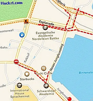
„iOS 7“: suaktyvinkite srautą ir eismo informaciją „Apple Maps“
- Atidarykite programą „Žemėlapiai“ ir bakstelėkite informacijos simbolį apatiniame dešiniajame ekrano kampe (žr. Paveikslėlį).
- Jei žemiau pasirinksite parinktį „Eismas“, visa informacija bus rodoma žemėlapyje.
- Keliai, pažymėti raudonai ir geltonai, šiuo metu yra smarkiai ar vidutiniškai grūstos. Maži simboliai taip pat rodo uždarymą, statybvietes ir pavojingas zonas.
- Pastaba: naudojant „iOS 6“ gali atsitikti, kad pirmiausia turite suaktyvinti eismo funkciją. Šį nustatymą galite rasti programos „Nustatymai“ skiltyje „Duomenų apsauga“> „Vietos paslaugos“> „Sistemos paslaugos“.
Kitame praktiniame patarime jums parodysime, kaip išsiųsti savo vietą per „Apple Maps“.